(UPDATE: Aug. 23 @ 3:15 pm) – Favourable weather conditions have “significantly reduced” fire behaviour and activity of the Briggs Creek wildfire, says the BC Wildfire Service.
Containment lines on the north east corner have also been completed near populated areas.
As a result of the downturn in fire activity and the rescinded evacuation alerts, the BCWS will remove the fire from the wildfires of note page on Thursday.
The agency says the fire is staying within containment lines and increased humidity has bolstered the work of firefighting crews.
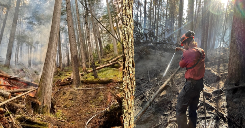
On Tuesday, there were 28 firefighters on site with the support of one helicopter.
Although this fire remains active, it has not yet been classified as being held.
So, people in nearby communities may continue to see smoke within the fire’s perimeter over the coming weeks.
(UPDATE: Aug. 22 @ 11:45 pm) – After more than a week of limited fire activity, the Briggs Creek wildfire is now estimated to be 2,160 hectares.
That’s an increase of 430 hectares from the previous estimate.
According to an update from the BC Wildfire Service, the larger size is due to more accurate mapping done over the weekend and some growth that happened last week.
The agency explains that heavy smoke around the wildfire made it difficult for helicopter crews to see the perimeter of the fire.
“It is common for estimated fire sizes to shrink or grow when it is able to be mapped,” explains the BCWS.
“Structures are not currently threatened by this fire and it remains well within control lines.”
An unstable weather pattern is expected to move into the region and will bring hot, dry conditions with the possibility of thunderstorms. This is expected to increase fire activity.
As of yesterday there were a little more than 50 firefighters on site with the support for one helicopter.
When the fire broke out on Aug. 1, it started in steep and mountainous terrain that was unsafe or inaccessible for ground crews.
However, the BCWS says as the fire burns downslope to existing cut blocks and roads, more crews members may be brought in to fight the fire in these safer areas.
(UPDATE: Aug. 21 @ 1:30 pm) – Fire activity and growth remain unchanged on the Briggs Creek wildfire west of Kaslo.
In an update from the BC Wildfire Service, the fire remains estimated at 1,730 hectares.
An evacuation alert from the Regional District of Central Kootenay remains in effect.
However, an unstable weather pattern has settled in the region and is expected to bring hot and dry temperatures.
Much of the Southeast Fire Centre is expected to be impacted by the prolonged warming and drying trend.
This has already caused rank three and four fire behaviour to be observed on the Briggs Creek wildfire. According to the BCWS, this means the fire is candling in taller trees and moving at a moderate to fast rate of speed.
“Thunderstorm activity is expected throughout the Southeast in the late afternoon and evening, though precise locations are undetermined at this time,” explains the BCWS.
“Precipitation should be confined to the area directly under passing storm cells, while surrounding areas are likely to remain dry.”
That risk of thunderstorms is expected to bring generally light winds, however, some gusting winds are anticipated as the storm front passes the area.
There are 53 firefighters and one helicopter on site Sunday.
Crews tackled a spot fire that broke out on the eastern containment line near an avalanche path.
Fortunately, the avalanche path acted as a natural fuel break which allowed helicopter crews to bucket water onto the run.
On other areas of the fire, crews are securing containment lines, extending water delivery systems and building hand guards.
(UPDATE: Aug. 16 @ 3:51 pm) - In recent days, activity on the Briggs Creek wildfire has remained relatively unchanged.
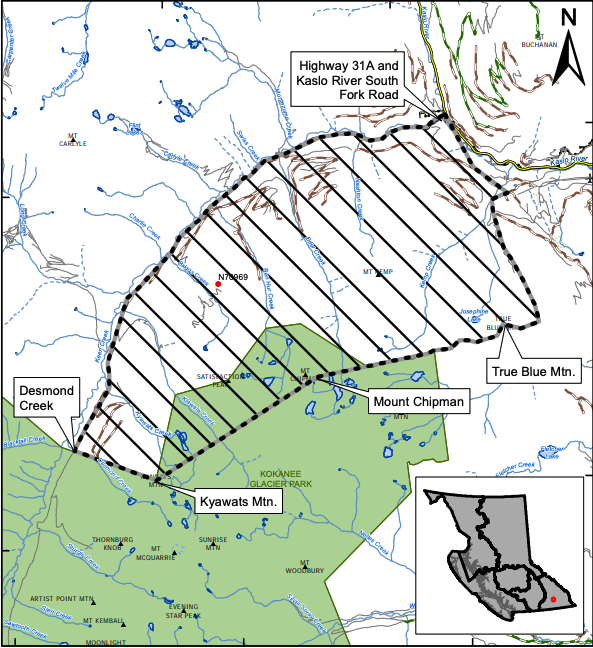
As the warming and drying trend continues, the fire is backing downslope towards containment lines on the north flank along the Nashton face, and at the west flank along Keen Creek.
Containment lines are situated on defensible ground that crews can safely access, and as the fire reaches these lines, ground crews will be able to safely use direct attack suppression strategies.
The type of timber at these lower elevations is less likely to develop crown fire, but as for the blaze in higher elevations, the timber type can be prone to more vigorous fire behaviour under certain conditions, which can make the fire more visible as it finds fuel.
BCWS crews have been on site early every day and remain there into the evening, as they continuously monitor conditions to ensure they are aware of any unwanted growth.
Crews also remain stationed locally and are available for a quick response in the event conditions change, but light winds have been easy to manage for the time being.
At this time there are 24 firefighters and one helicopter on scene, additional helicopters can also be assigned to this incident to provide bucketing support if requested.
While wildfire management relies on a fleet of reliable and capable aircraft to assist firefighters on the ground, there are several incidents where the use of aircraft can have unintended negative consequences and be counterproductive.
Bucketing in steep terrain can wash burning debris downslope, sending the fire down the slope.
In steep terrain with heavy fuels like the Briggs Creek fire, crews on the ground are needed to bolster the work being done by aircraft.
When crews are unable to safely access a fire, the chances of bucketing having a negative effect significantly increases.
“Public and responder safety is our number one priority, and this includes the safety of the pilots. Flying is a high-risk activity, and sustained bucketing at high altitudes significantly increases that risk,” said a release from BCWS.
“The significant safety risk to both fixed and rotary wing pilots, no structures being threatened at this time, and the possibility of negative impacts are why residents are not seeing aerial resources on this incident.”
Helicopter reconnaissance will continue to be focused along key areas of the fire – Kemp Creek Ridge, northeast and northwest corners - wherever the fire is nearest to containment lines.
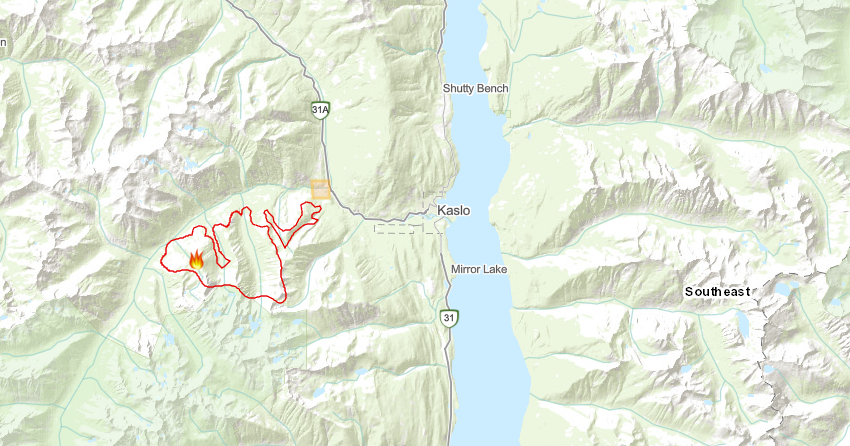
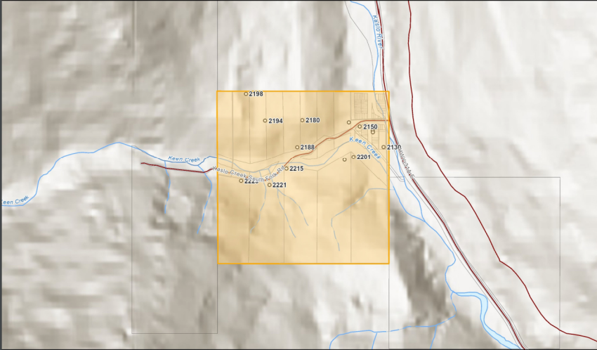
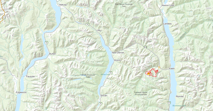
The Briggs Creek wildfire is estimated to be 1,730 hectares just 11.5 km west of Kaslo, and an evacuation alert remains in place for properties on Kaslo Creek South Fork road in Electoral Area D.
(UPDATE: Aug. 14 @ 12:30 pm) – After more than a week, the BC Wildfire Service has recorded some growth on the Briggs Creek wildfire west of Kaslo.
It is now estimated at 1,703 hectares.
Windy conditions are to blame for the growth.
“The consistent winds on August 13th pushed the fire away from our containment lines along the east and north flanks,” explains the BCWS in an update on Sunday.
“As forecast, strengthened winds and elevated temperatures did increase smoke and fire behaviour compared to recent days; however, crown fire involvement was not observed.”
However, sections of the fire are approaching old cutblocks and a series of roads which will act as fuel breaks.
As conditions allow, crews will conduct small scale hand ignitions to ensure the fire doesn’t gain upslope momentum.
Patrols are ongoing on the northeast corner while mop-up continues on other flanks.
There are 10 firefighters and one helicopter assigned to this fire.
This continues to not be an interface fire, however, an area restriction is in place. For more information, click here.
(UPDATE: Aug. 7 @ 11:20 am) – The Briggs Creek wildfire, located west of Kaslo, has not experienced any “substantial growth” in the past 24 hours.
The BC Wildfire Service says the lightning-caused wildfire continues to not threaten any structures and remains estimated at 1,679 hectares.
On Sunday, there are 14 firefighters on site with the support of one helicopter.
However, it continues to be very visible to Kaslo and surrounding areas. The agency says fires tend to look closer or bigger at night because of the glow they emit in the dark.
Additionally, the agency says the wildfire continues to burn in a desirable area and is not threatening containment lines.
This fire "is primarily displaying characteristics of a smouldering ground fire with a desirable slow rate of spread,” explains the latest update from the BCWS.
“We are anticipating that forecasted seasonal hot and dry conditions will result in the fire exhibiting some higher intensity pockets of fuel consumption.”
At this time, the fire continues to burn at higher elevations in steep terrain and has been met with a change in fuel type that is not burning as easily.
An incident commander is on site to monitor any unwanted fire growth and personnel will maintain a constant presence to act accordingly if the fire does begin to grow when temperatures increase later this week.
(UPDATE: Aug. 4 @ 6:15 PM) - Over the past few days the Briggs Creek wildfire hasn't seen any sort of significant growth.
A more accurate track of the perimeter has measured the size of the fire to 1,680 hectares.
At this time the fire continues to maintain its position high on the slope, while it has moved down slightly it has been met with a change in fuel type that is not easy to burn.
The fire remains very visible to the town of Kaslo and surrounding areas, and in the evening hours, the fire is magnified by the darkness and may appear closer than it is.
The Regional District of Central Kootenay has implemented an evacuation alert in the vicinity of this fire, and more information can be found here.
There are currently nine firefighters on the scene, along with one helicopter. With the fire burning in step, and unworkable terrain, heavy equipment isn't needed at this time.
(ORIGINAL STORY: Aug. 2 @ 5:05 PM) - A fire caused by a lightning strike near Briggs Creek has ballooned to 1,500 hectares in size.
It is estimated that the fire is 11.5 km west of the town of Kaslo. The Regional District of Central Kootenay (RDCK) has implemented an evacuation alert, for many properties on South Fork Road in Kaslo.
It is moving fast at a high elevation away from properties and into the remote areas of the Kokanee Glacier Park.
Currently, 29 firefighters are on scene, with a 20-person crew en route.
Because of the steep terrain, direct attack of the fire is challenging and inaccessible.
Ground crews are working on establishing control lines in operable ground that will provide a safe, defendable space to carry out suppression activities.
NowMedia will continue to update the story as more information is provided.


